
Drone Spots in South America: Top 12 Locations for Pilots in 2026
The most beautiful drone spots in South America — My ultimate guide
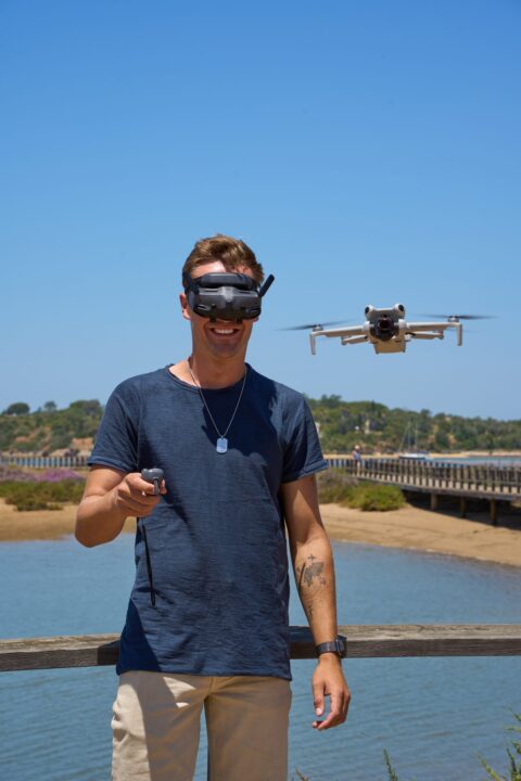
South America is made for drone photography. Endless coastlines, surreal desert landscapes, gigantic glaciers, and rainforests stretching to the horizon. In five trips across the continent, I explored this region with my DJI Mini 5 Pro I've completed hundreds of flights and found the most spectacular spots. Here are the best drone locations in South America — with GPS coordinates, legal information, and my personal tips.
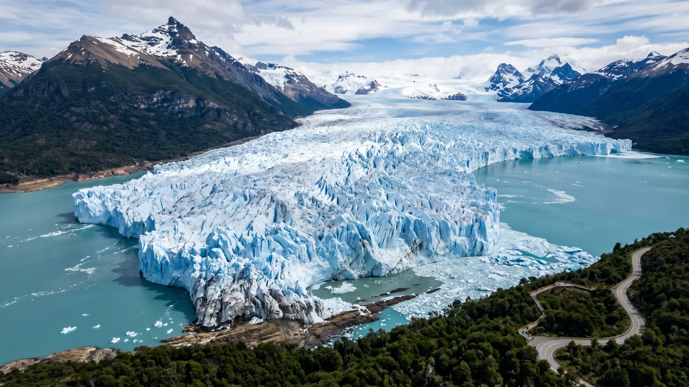
- Most dramatic spot: The Perito Moreno Glacier in Argentina is 5 km wide and 60 m high; best flight time is from October to March with winds below 30 km/h.
- Most surreal effect: From January to March, the Salar de Uyuni becomes the world's largest mirror, ideal for watching the sunrise at the level of Isla Incahuasi.
- Legal key: Drones under 249g (e.g. DJI Mini 5 Pro) bypass most of the bureaucracy in Argentina, Brazil, Chile and Colombia — Venezuela confiscates them completely.
- Coastal highlight: Lençóis Maranhenses offers full turquoise lagoons between white dunes from June to August — arrival by 4x4 guide from Atins or Barreirinhas.
- At 5,200 m on Rainbow Mountain, the Mini 5 Pro loses significant lift — short flights under 10 minutes and use ND filters plus CPL for colors.
Drone rules in South America — What you need to know
Before we get to the locations: Drone legislation in South America is a patchwork. In some countries it's straightforward, in others you need a permit, and in a few it's practically forbidden. Here's an overview:
| country | status | Details |
|---|---|---|
| Argentina | Free (under 500g) | Online registration with ANAC is free. |
| Brazil | Free (under 250g) | ANATEL registration required, 120m maximum altitude |
| Chile | Free (under 250g) | DGAC registration, max. 120m, not above people |
| Colombia | Free (under 250g) | Simple online registration |
| Peru | Regulated | Approval from DGAC is required, can take weeks |
| Bolivia | Grey area | No clear rules, tolerated in tourist areas |
| Venezuela | Forbidden | Military classification, drone is confiscated. |
Argentina — Glaciers, Pampas and Patagonia
1. Perito Moreno Glacier
Arguably the most dramatic drone spot in South America. The glacier is 5 km wide, 60 m high, and calves regularly—tons of ice break off and plunge into the turquoise water. From above, you can see the structure of the ice: deep blue crevasses, white ridges, and the interplay of colors between the glacier and Lago Argentino. My drone flight here produced my most-shared reel of 2023.
Starting position: Viewing platforms on the south arm (-50.4967, -73.1367)
Best time: October-March (summer)
Warning: Wind gusts up to 60 km/h are normal — only fly in calm weather!
2. Fitz Roy, El Chaltén
The granite spires of Fitz Roy at sunrise—when their peaks are bathed in orange light (alpenglow in South American terms). From the drone, you can see Laguna de los Tres and the glacier tongue behind it. A motif that should be in every photographer's portfolio.
Starting position: Mirador Laguna de los Tres (-49.2800, -72.9567)
Hike: 4-5 hours to the starting point — take the drone in your backpack
Best time: December-February, sunrise from 5:30 am
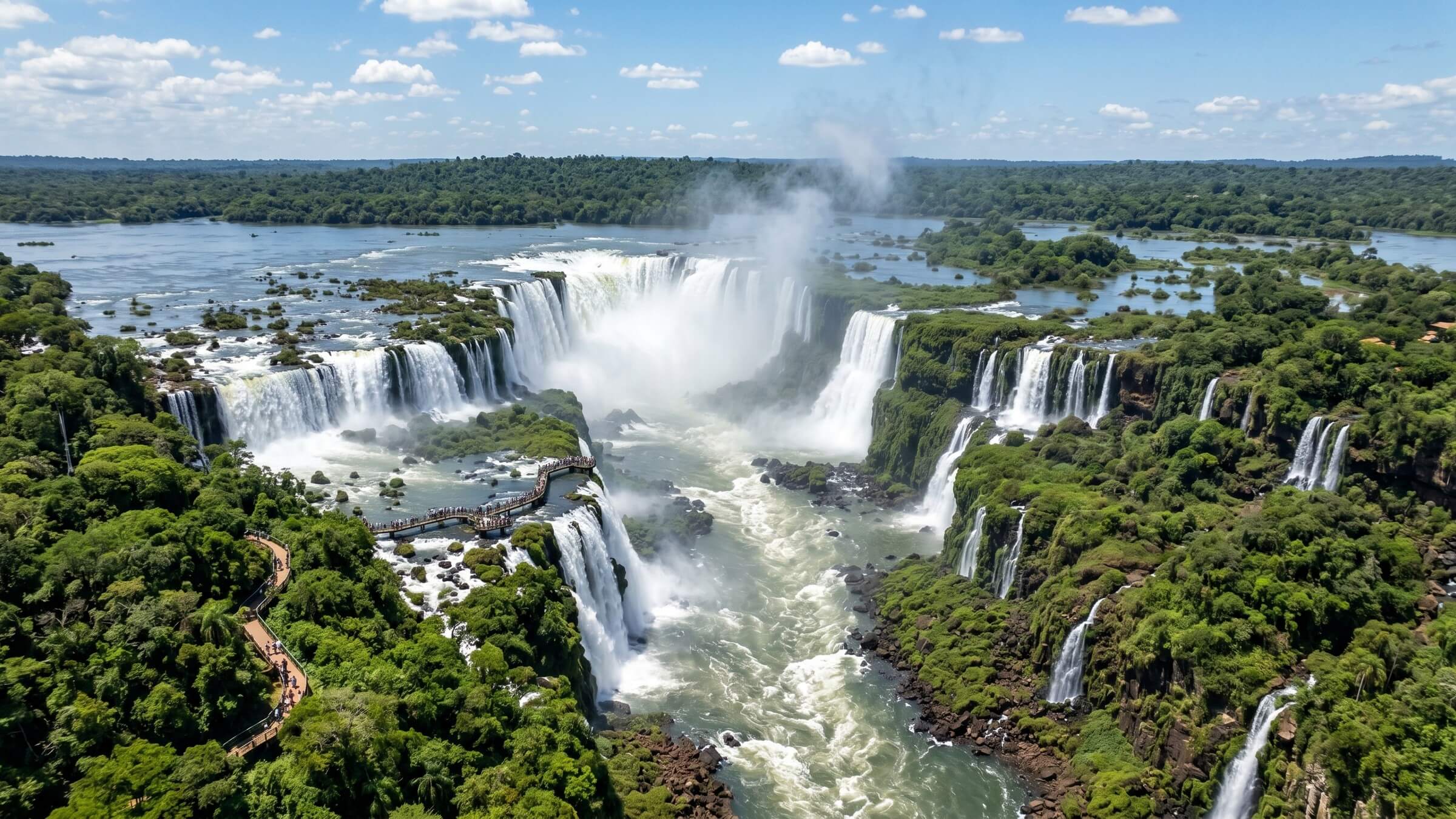
3. Iguazu Falls
275 individual waterfalls, the largest waterfall chain in the world. From a drone, the scale is overwhelming — the "Garganta del Diablo" (Devil's Throat) is an 80m deep basin into which water plunges from all directions. The spray creates permanent rainbows.
Brazil — Coast, Jungle and Rio
4. Lençóis Maranhenses
White sand dunes with turquoise rainwater lagoons — it looks like a mirage, but it's real. From the drone, you can see the pattern: dozens of lagoons nestled among the dunes, some 100 meters long. After the rainy season (May-September), the lagoons are at their fullest and the colors at their most intense.
Starting position: Atins or Barreirinhas
Best time to go: June-August (lagoons full, little rain)
Hire a guide with a four-wheel drive to take you to the remote lagoons — there you'll be alone.
5. Rio de Janeiro — Christ the Redeemer statue and Sugarloaf Mountain
The world's most iconic cityscape from above. Copacabana Beach, the Christ the Redeemer statue, Sugarloaf Mountain, Guanabara Bay—all in a single drone panorama. BUT: Rio has a no-fly zone around Santos Dumont Airport and Corcovado Mountain. I flew from Praia de São Conrado—legally, safely, and with a perfect view of the skyline.
Best time: April-September (less haze, clearer visibility)
Maximum height: 120m (strictly in Rio)
6. Fernando de Noronha
Perhaps the most beautiful archipelago in Brazil: volcanic rocks, turquoise waters, turtles, and dolphins. The drone's perspective reveals the bizarre rock formation "Morro Dois Irmãos" and Baía do Sancho (according to TripAdvisor, the best beach in the world). Drone flights require permission from the ICMBio park authority—apply online; processing time is 5-7 days.
Chile — Desert, Lakes and Volcanoes
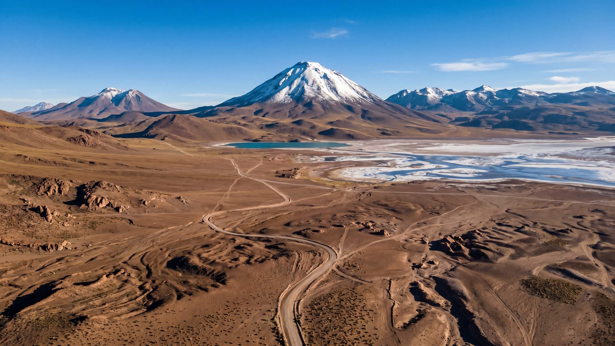
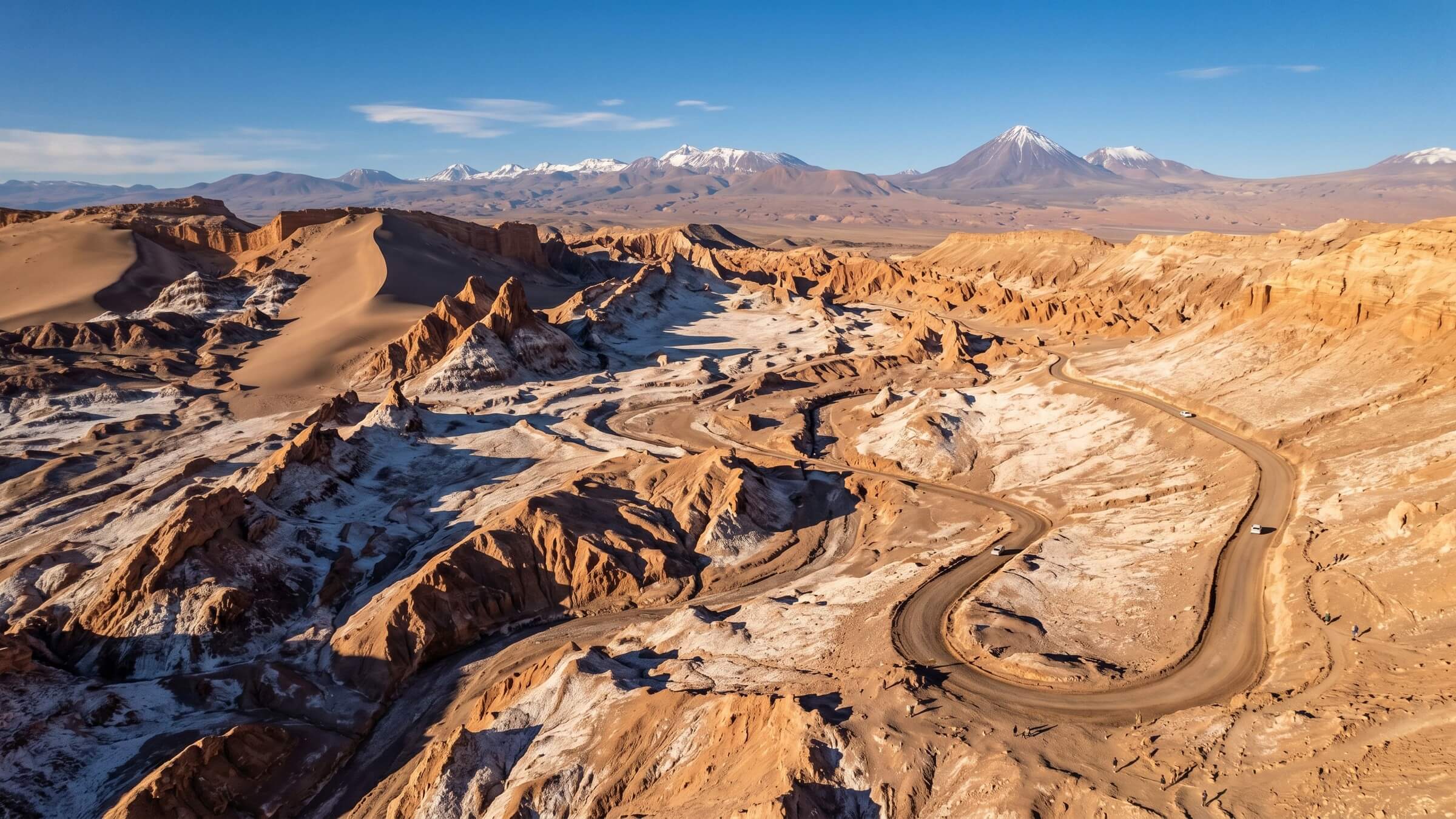
7. Atacama Desert — Valle de la Luna
The driest desert in the world — a Martian landscape on Earth. From the drone, you can see the salt formations, the eroded rock formations, and the endless expanse in all earth tones: red, orange, brown, white. At sunset, everything turns deep gold and violet.
Starting position: Mirador Valle de la Luna (-22.9133, -68.2933)
Best time: Year-round (it never rains), sunset is perfect.
Insider tip: Flying on a full moon — the desert in moonlight from above is surreal.
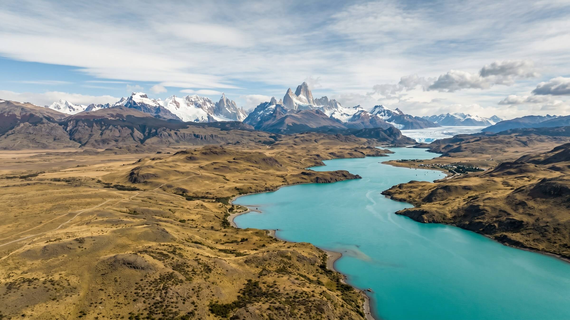
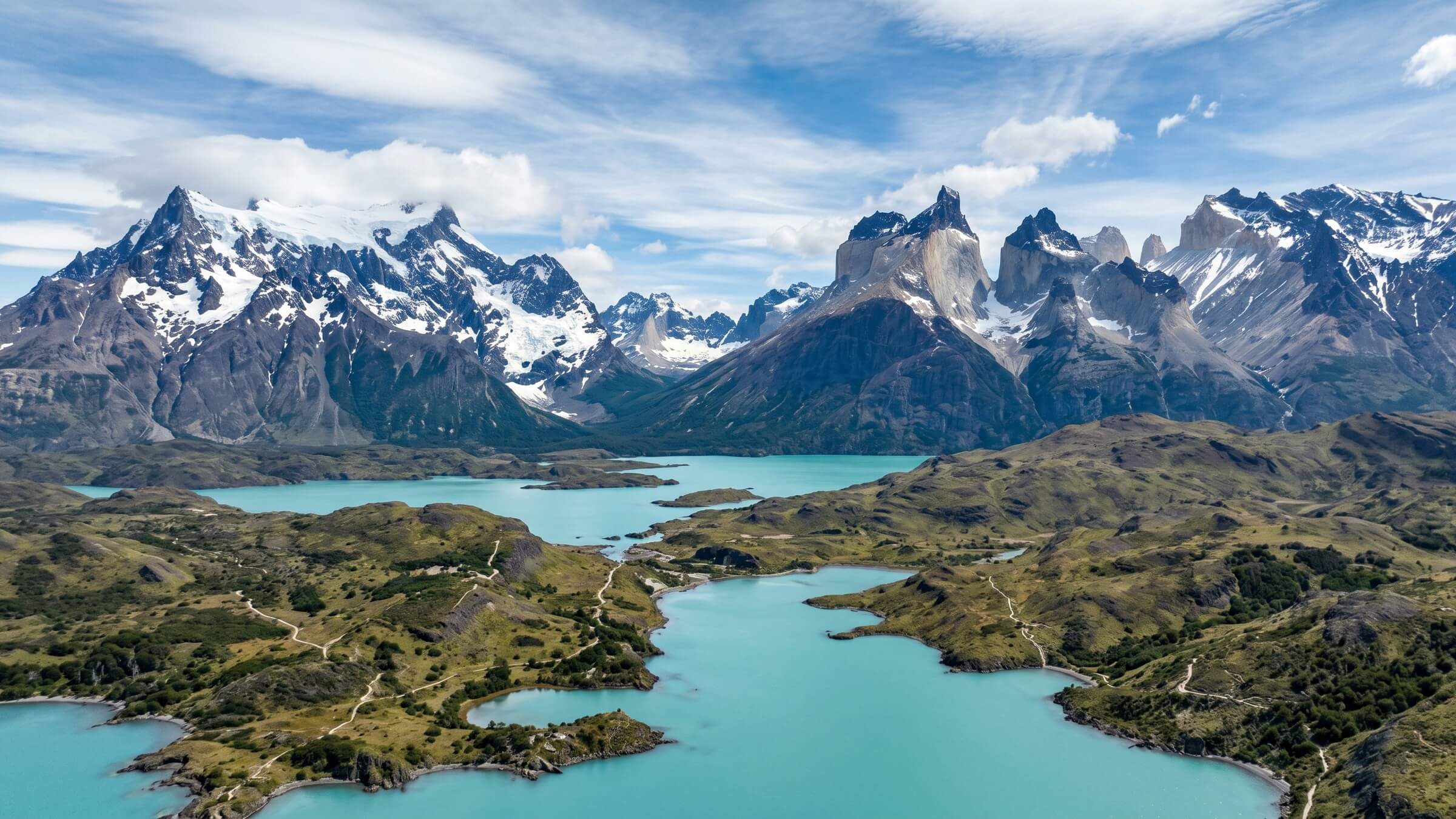
8. Torres del Paine — The highlight of Patagonia
The three granite towers that give the park its name are even more imposing from a drone than from the ground. The view over Lago Grey with its icebergs, the grey granite towers, and the endless steppe in the background—a panorama that surpasses any desktop background.
Colombia — Caribbean from above
9. San Andres and Providencia
The "Sea of Seven Colors"—and from the drone you can see all seven. The water changes from deep blue to turquoise to emerald green, interspersed with sandbanks and coral reefs. Providencia (rebuilt after Hurricane Iota in 2020) is even more spectacular: fewer tourists, a wilder landscape, pristine reefs.
Starting position: Johnny Cay from the coast of San Andrés
Best time to visit: February-April (clearest water)
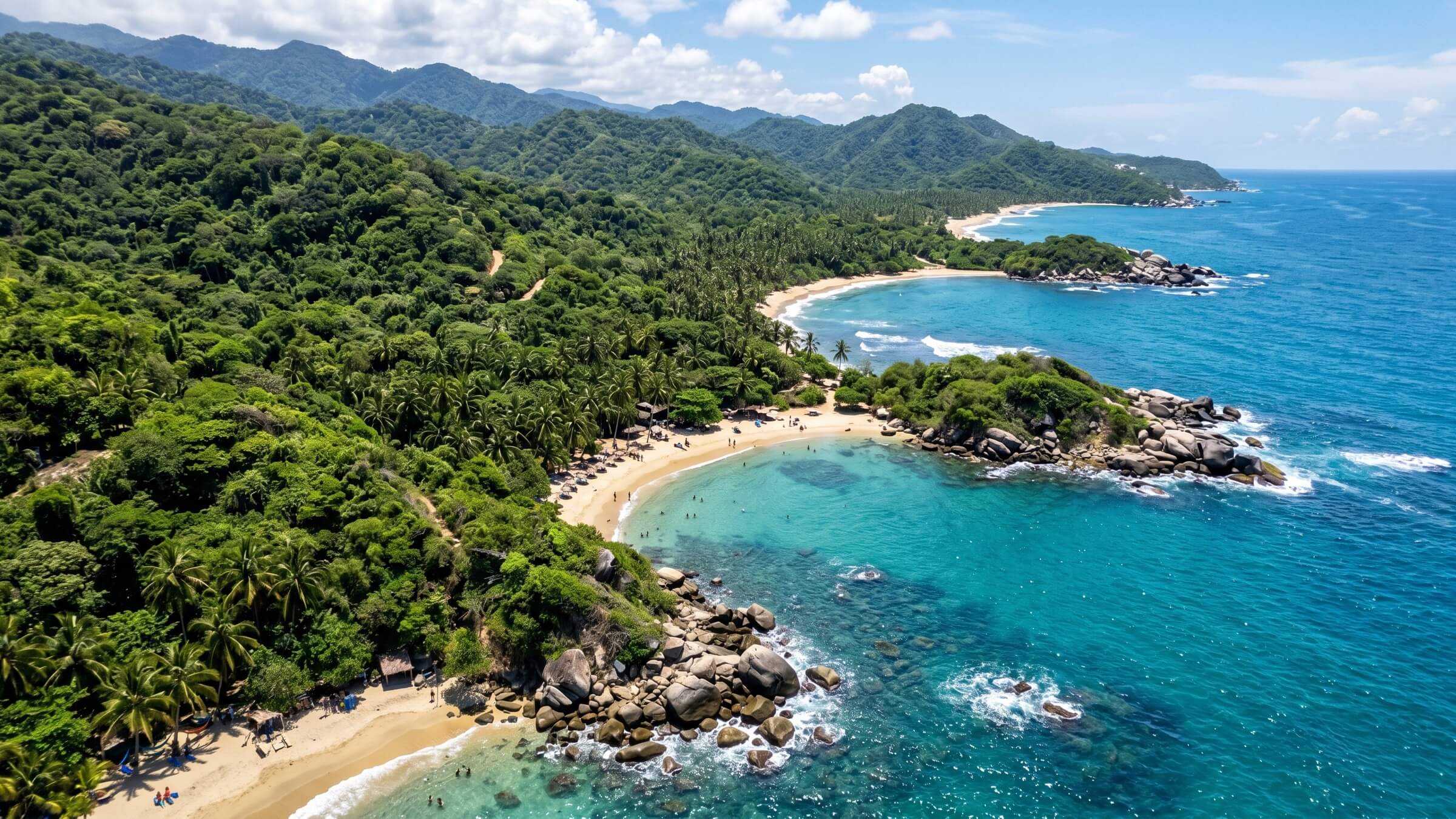
10. Cocora Valley
Sixty-meter-high wax palms in a green valley shrouded in mist—from a drone, it looks like a scene from Jurassic Park. The aerial perspective reveals the incredible height of the palms in relation to the landscape. The best shots are taken in the morning when the mist drifts through the valley.
Best time: 6-8 am (fog + light)
Starting position: Valley entrance near Salento
Bolivia — Surreal Landscapes
11. Salar de Uyuni
During the rainy season, the world's largest salt flat becomes the world's largest mirror. From a drone, the effect is breathtaking: you literally see double—sky and earth merge. In the dry season, on the other hand, the geometric salt patterns—gigantic hexagons stretching to the horizon—are revealed.
Starting position: Isla Incahuasi (-20.2417, -67.6267)
Rainy season: January-March (mirror effect)
Drying season: June-October (salt pattern)
Fly at sunrise or sunset — the reflections are most intense then.
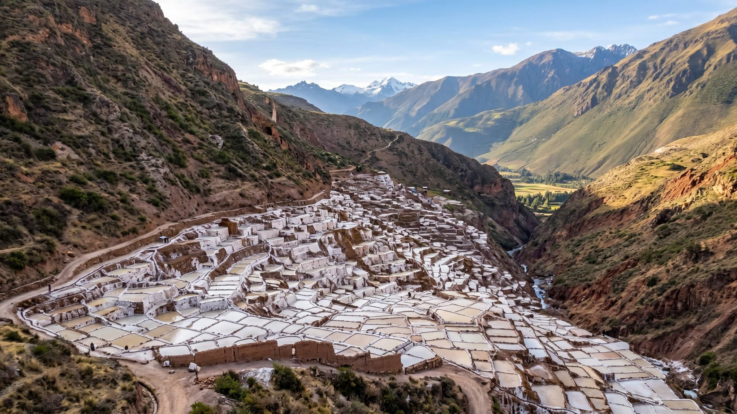
Peru — Mountains and Ruins
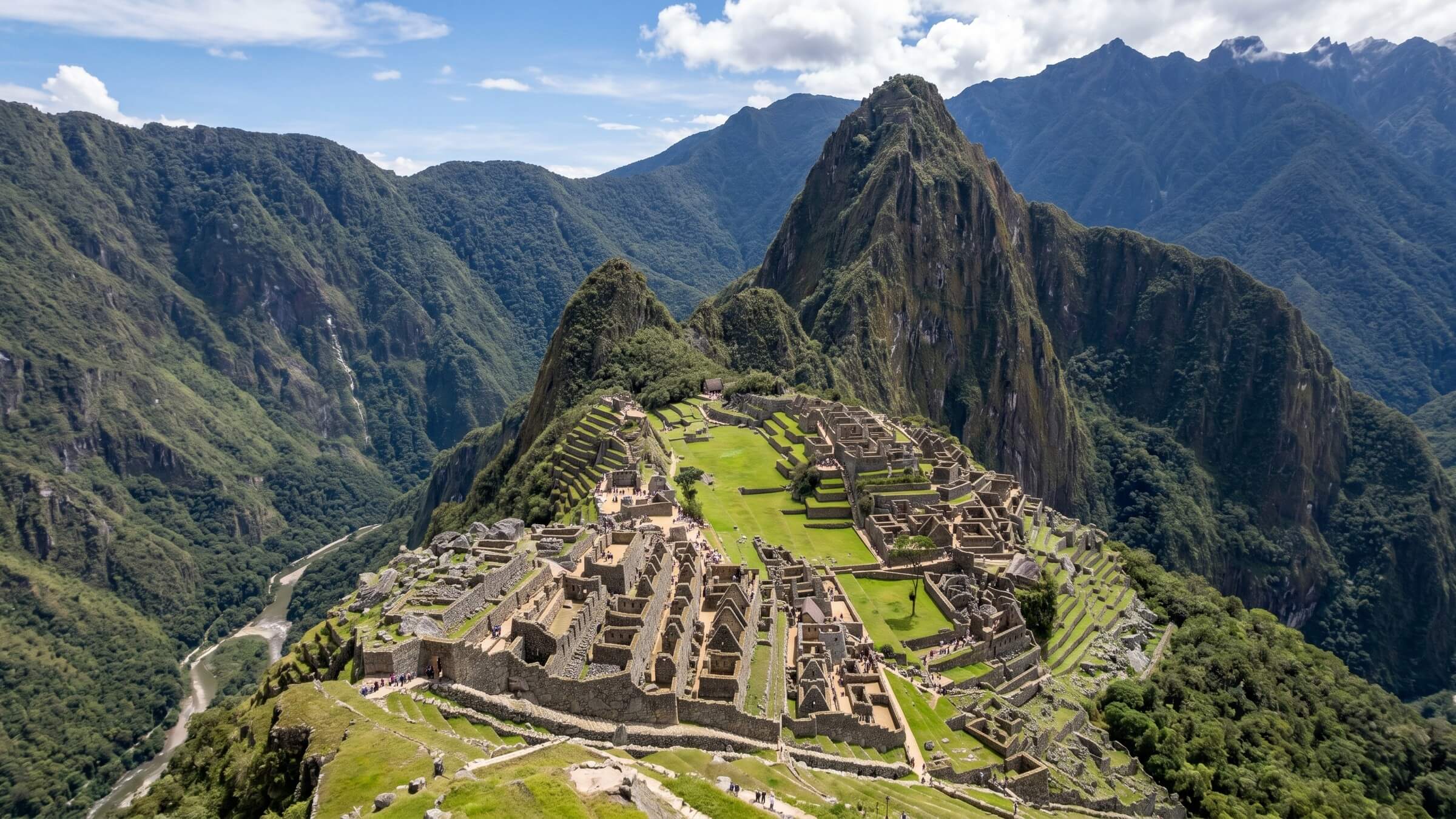
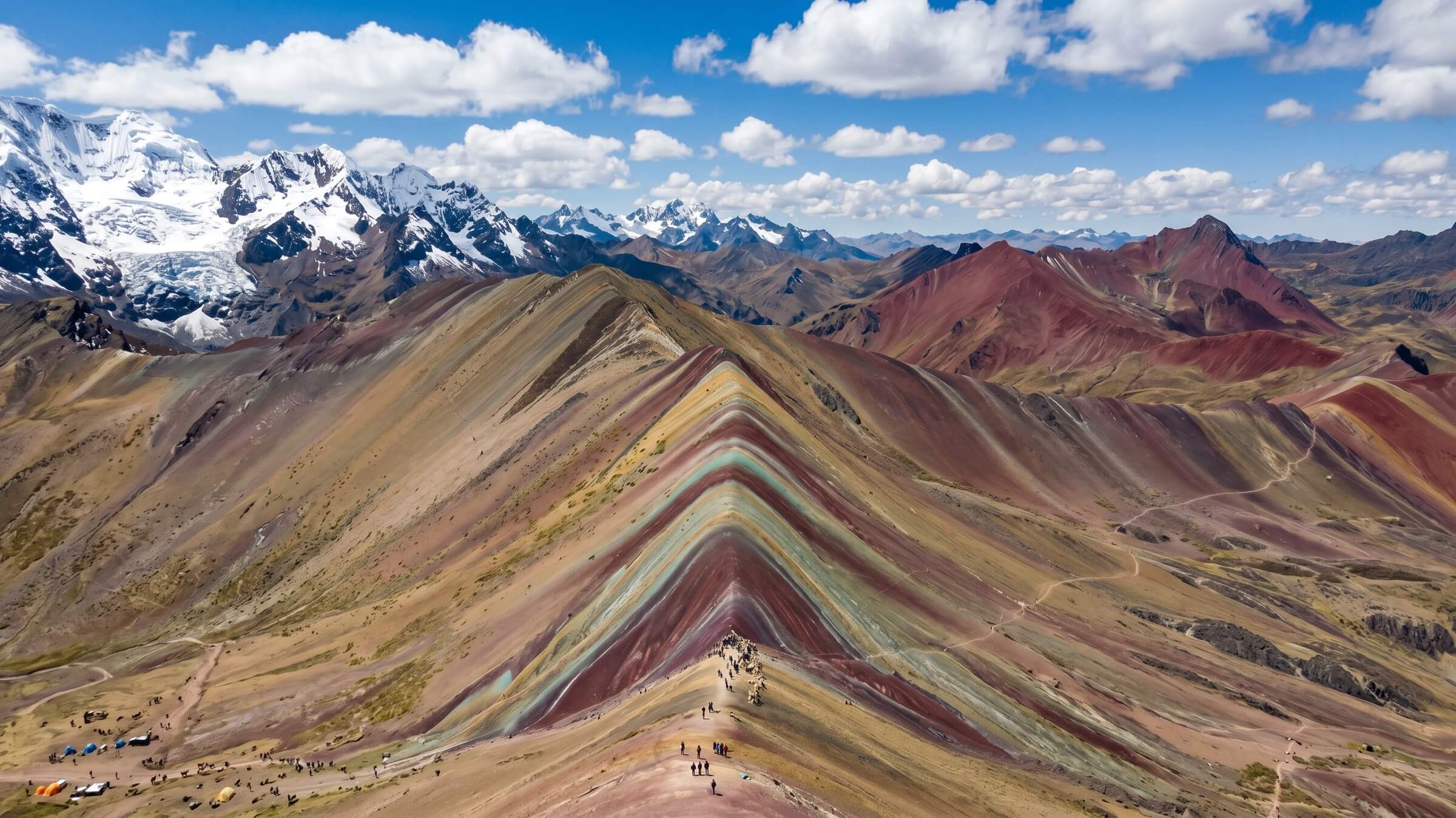
12. Rainbow Mountain (Vinicunca)
The "Rainbow Mountain" at 5,200m altitude — layers of earth in red, yellow, green, turquoise, and violet. From the drone, you can see the entire color spectrum and the surrounding snow-covered peaks. Important: At this altitude, the DJI Mini 5 Pro Significantly less lift. Short, controlled flights, never further than 500m.
My drone settings for South America
| situation | Attitude |
|---|---|
| Glacier/snow | ISO 100, exposure compensation +0.7 (snow reflects strongly) |
| Desert/Sand | ISO 100, ND16 filter, manual white balance (5500K) |
| Coast/Sea | ISO 100-200, CPL filter for colors, 48MP instead of standard |
| Rainforest/Jungle | ISO 200-400, low flight altitude (below 50m), slow movements |
| Altitude (over 4000m) | Short flights (max 10 min), careful take-off, propeller check |
FAQ — Drone photography in South America
Can I take my drone to South America?
Yes — drones under 249g (like the DJI Mini 5 Pro) are generally not a problem in most countries. Batteries go in hand luggage, the drone can go in checked baggage or hand luggage. Venezuela is the exception: drones are confiscated at customs.
What is the Wi-Fi/mobile network quality for live view?
Irrelevant — the DJI Mini 5 Pro connects directly to the controller via OcuSync, not via cellular data. You don't need internet for the flight, only for the upload afterwards.
How do I deal with wind in Patagonia?
Patagonia has notorious winds (60-80 km/h is normal). My rule: Only fly when the wind is below 30 km/h. The DJI Mini 5 Pro can handle up to ~38 km/h, but with a safety margin. The wind is usually weakest in the morning (6-9 am).
What do I do if the drone crashes?
In 287 flights in 2024, I had zero crashes—the obstacle avoidance of the Mini 5 Pro is excellent. Nevertheless: Take out DJI Care Refresh (insurance for ~€70/year). A replacement will be delivered within 5 days.
Which image editing software do I use for drone photos?
Lightroom — same workflow as for the Sony. I shoot in RAW (DNG format), edit in Lightroom with custom presets, and export at maximum quality. For panoramas, I use the integrated DJI panorama function (2x3 or 360°), which stitches automatically.
Max Haase
Travel Content Creator · Drone Photographer · Visual Storyteller
A professional travel creator for over 10 years with over 4.2 million followers. Specializing in high-end tourism board collaborations and visual travel storytelling.


